The Venetian Walls of Heraklion
Walking the Venetian Walls of Heraklion
Many centuries ago, Heraklion was considered so important to its Venetian occupiers that they built a set of walls strong enough to withstand a siege that lasted a staggering 21 years and cost the lives of many, many fighters on both sides: Venetians and Cretans on one side, and Turks on the other.
Heraklion walls are more than four and a half kilometers in length, and everywhere wide and strongly built in a triangular shape, it encompasses what we might call ‘Old Heraklion’ in a series of straight lines between its original seven ‘bastions’, or individual forts, and five gates, with the sea as its base.
I am no historian and can only provide a few facts. For a much more detailed account of the history, I recommend a visit to the Historical Museum of Heraklion. This way, you will have an idea of the ferocity of battle that gunpowder, grenades, and cannon brought to test the strength of the walls, and of the determination shown on each side to succeed. It is said that the Turks lost 100,000 fighters, to the defenders 30,000. It is true to say that the fighting was savage, and was recalled centuries later by an Herakliot who wrote a poem in 1941, as German soldiers seemed to be marching towards the gates, that began:
“Come on, German! These stone walls have seen more blood than you’ll ever know…”
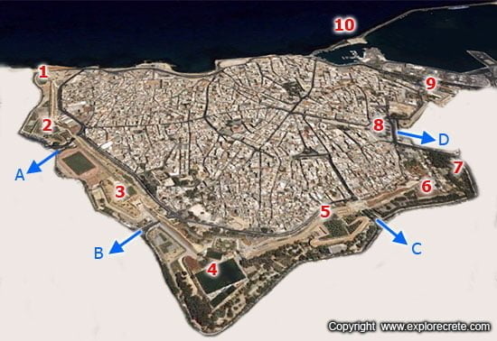
No 01: Saint Andrew bastion
No 02: Pantocrator bastion
- gate A: Chanioporta (Chania gate)
- No 03: Bethlehem bastion
- gate B: Bethlehem gate, or Komeno Bendeni
- No 04: Martinengo bastion and Kazantzakis Tomb
- No 05: Jesus bastion
- gate C: Kainouria Porta (New Gate)
- No 06: Vitouri bastion
- No 07: Georgiadis Park
No 08: Eleftherias Square
gate D: Pili Agiou Georgiou (Saint George Gate)
No 09: Sabbionara bastion
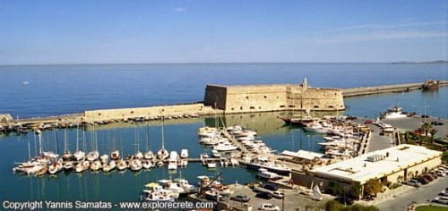
No 10: Koules fortress
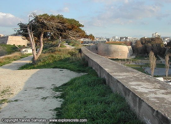
The top of the Heraklion walls can be quite beautiful now, with long grass, trees, hedges and flowered pathways high above Heraklion’s city streets. It’s not paradise, but it is soft by Heraklion standards. Here and there toward the eastern side you will find that the path is still rough, and work is indeed continuing to both improve access to the walls and open up more areas of this unique feature of Heraklion.
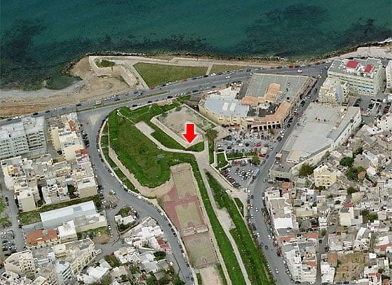
We start the walk on the Venetian walls of Heraklion at their westernmost bastion, St Andrew. To reach it, head on foot or by taxi to Agios Andreas, normally travelling on the coast road called Makariou to the west of the city. Like its partner on the opposite eastern flank, it was, as we know, a weak point in the battle between Venetian overlords and Ottoman Empire-building Turks. Today, the view from the western end of the walls outwards towards the mountains, and inwards across Heraklion to the sea, gives an idea of the scale of this city of 200,000 people.
Walking east, we leave the Bastion of Agios Andreas (Saint Andrew) and shortly arrive at the Bastion of the Pantocrator (“the Ruler of All”= Jesus). From here the brilliance of the fortification, designed by the Venetian architect Michelli Sanmichelli, becomes clear.
On levels below each of the seven bastions, but above the wide ditch, were formed flat squares where artillery would have been placed. These cannons must have been ideally positioned to defend not only the trench in front of them, but each adjoining bastion. We can see right across the city as far as the sea, and soldiers would have been able to keep watch over the city, and on the movements of its inhabitants. The walls and heart-shaped bastions feel strong and unbreakable, even today, amidst the surrounding modern architecture.
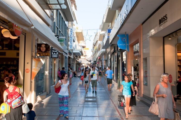
Here is today’s main gateway to western Crete, well described in the Kazantzakis novel ‘Freedom and Death’, where some grudging co-existence with the Pasha must have been maintained.
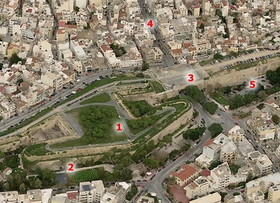
PHOTO:
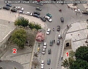
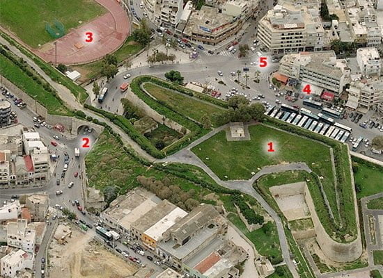
No 1: Pantocrator bastion
No 2: the gate of Chanioporta, which means “Chania gate” because this used to be the entrance from other towns in western Crete
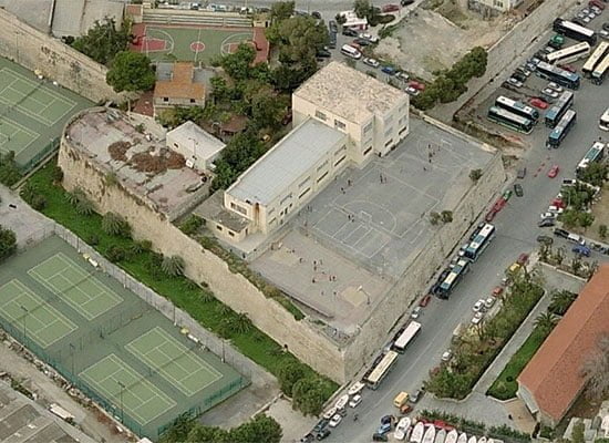
No 3: Stadium of Korakas
No 4: Bus station to Gortys, Phaistos, Matala and other towns in the southern part of Heraklion prefecture
No 5: 62 Martiron avenue, which leads to the western suburbs of Heraklion and the coastal area of Amoudara. Είναι επίσης ο δρόμος που οδηγεί στην έξοδο προς το εσωτερικό και τη νότια ακτή του Νομού Ηρακλείου, όπως και στην έξοδο για δυτική Κρήτη (Αγία Πελαγία, Φόδελε, Μπαλί, Ρέθυμνο, Χανιά).
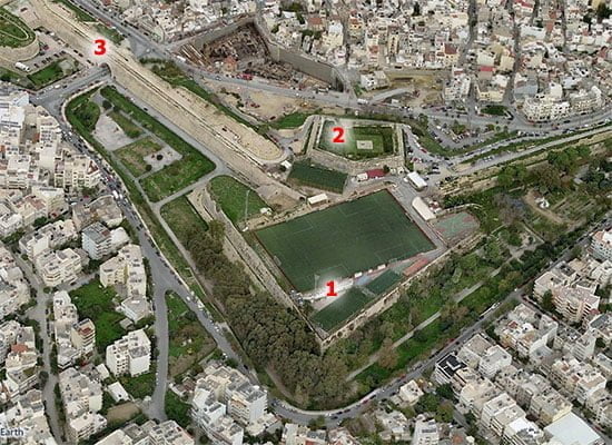
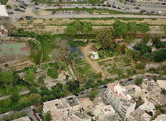
As we make our way to the Bethlehem Bastion, can see new developments that ensure some respite from the sea of concrete that the city can appear to be. Much of the land which formed the trench just beyond the walls was given to the people after the last war, for public use. This is one of my favourite spots to look inward on the city and the spires of Saint Minas Cathedral.
PHOTO:
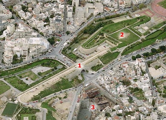
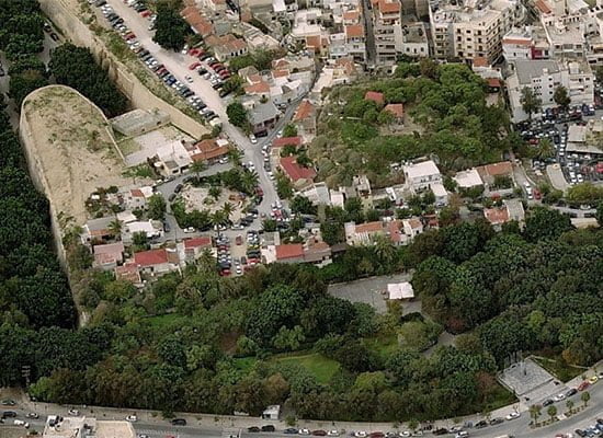
No 1: Bethlehem gate or Komeno Bendeni
No 2: Bethlehem bastion
No 3: Construction site for the Heraklion Cultural Centre
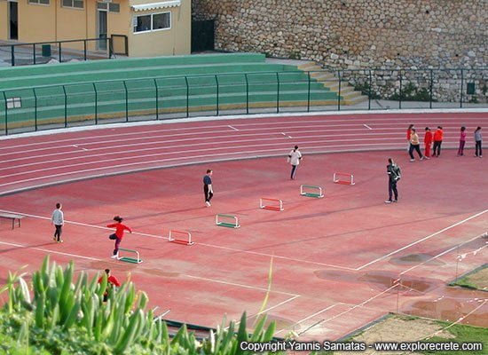
The walkway looks down on well-used athletics fields.
We are walking slightly uphill at this point, to reach the highest point, the Bastion of Martinengo. The walls are impressively wide here too, and open up to offer plenty of space and shade to give the visitor the opportunity to sit in comfort and enjoy the atmosphere high above the streets.
Martinengo is formed like a huge spear-head projecting south, its bastion tapering outward toward its base in the characteristic shape of early Mediterranean defences. Apart from being home to Ergotelis, Heraklion’s second football team, this is also the spot where Nikos Kazantzakis lies buried in a simple tomb.
PHOTO:
No 1: Martinengo bastion
No 2: The tomb of the author Nikos Kazantzakis on the Martinengo cavalier
No 3: The gate of Bethlehem, or Komeno Bendeni as it is usually called by the people of Heraklion
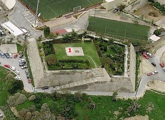
Nikos Kazantzakis tomb is located on the cavalier of the Martinengo bastion. Cavaliers were additional fortifications, that improved the surveillance of the area beyond the ditch
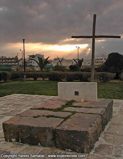
Eleni, his wife, died in 2004 and she was placed in a similar tomb nearby, strangely separated from her husband by a square of low hedges. On top, people come to walk, to read, play dice, flirt, and maybe just hang out, as in every other city in the world.
PHOTO: Nikos Kazantzakis tomb
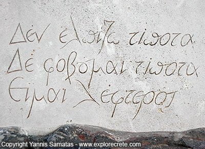
The inscription with the famous words of Kazantzakis:
I hope for nothing. I fear nothing. I am free.
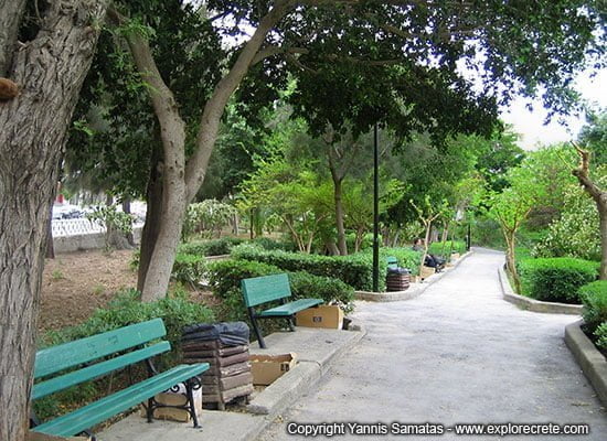
The environment is still very green and well-cared for at this point, and municipal gardeners are kept busy tending the flowers and shrubs during summer. Below us, just outside the walls, we can see the municipal garden centre (PHOTO) where trees and plants are cultivated all year round to stock the public spaces of Heraklion. The park which lies below us features a picnic area under the trees with a refreshment kiosk and children’s play areas. This park is also open to the public and makes a fine walk in itself, outside the walls.
Still walking east, we cross the New Gate, the last of such portals to be built, giving onto what would have been important routes to the south of the island. It was known to the Venetians, like the bastion that adjoins it, as Jesus Gate.
After the New Gate, in Greek Kainourgia Porta, we are again able to descend by Venetian steps to the streets below, and can be in the town centre in less than ten minutes, although there is more to see upon the walls, as we look down from the outside onto Heraklion’s outdoor theatre.
The Kipotheatro Kazantzakis is where many prestigious events and smaller ‘happenings’ take place during the summer festival between June and September. It really is a beautiful venue, nestling inside the walls that offer perfect acoustics, hosting all varieties of concerts, dance and theatre.
The open-air café called Oasis next to it is perfect, and hence popular, for a pre-theatre drink and a snack. Everyone knows this corner, and the buildings around it, as ‘Oasis’, so it’s easy to find.
PHOTO:
No 1: Jesus bastion
No 2: Kazantzakis open theatre, also known as Oasis
No 3: New Gate or Kainouria Porta in Greek
No 4: Evans street to Kornarou square and the centre of Heraklion
No 5: Parking lot inside the trench around the Venetian walls
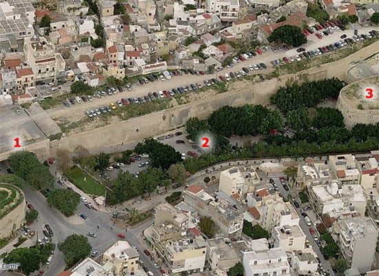
No 1: Jesus Gate or Kainouria Porta (New Gate)
No 2: parking lot
No 3: Vitouri bastion
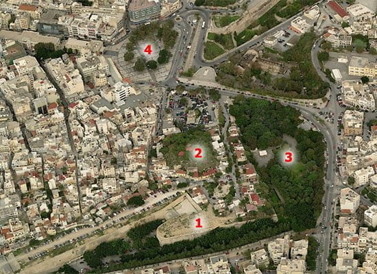
From Martinengo the next bastion on our route is Vitouri, where many people come in summer to enjoy the public garden below.
PHOTO:
No 1: Vitouri bastion
No 2: the neighbourhood of Vigla
No 3: Georgiadis Park
No 4: Eleftherias square
The park which you will notice below us is a cool place to relax and it is known as Georgiadis park, named after the Mayor of Heraklion who was executed by the German army in World War 2.
From Vitouri, the walk is downhill, with several paths to explore, some very close to the vertiginous drops on the outside.
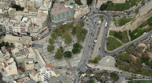
We are almost at Eleftherias Square, the busiest intersection of roads in the city, but our walk does not end there. The section of wall beyond Vitouri and its portal, the Lazaretou Gate or of Saint George, has been damaged greatly by battle, earthquake and indiscriminate demolition to make way for urban development.
We cannot continue on top of the walls to the sea, although from street level many structures exist, some having been incorporated into newer buildings. However, as we pass from the bastion to our last descent, it is worth recalling that the Greeks alone did not choose the fate of Heraklion, and now are, for the most part, keen to build upon what beauty remains in architecture and in nature, both of which have been uncommonly kind, and cruel, to Heraklion.
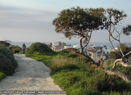
Step down to Plateia Eleftherias past the tiny settlement of Vigla (PHOTO). Say hello, or ‘yia sas’ to the locals you might meet on the way, they’ll love it. The track leading down offers a pleasant square with several good tavernas that local people favour, and the houses that you see are older in design than in many parts of town.
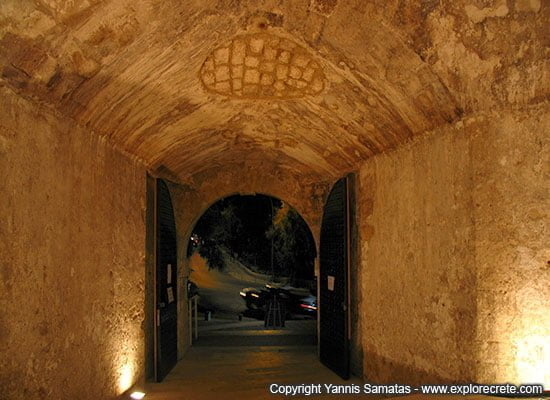
We now arrive at the big Plateia, dedicated to freedom and unity. A well known square, it is here we find the Archaeological Museum and many tourist shops, as well as a pleasant walk back to town. I recommend looking here for the entrance to St. George’s Gate (PHOTO), now restored and wonderfully atmospheric, as a walkway to the main passenger harbour and bus station.
If you have time, see the largest section of Giorgiades Park, just off the square and in the shadow of Heraklion’s great walls. The whole area around here is worth exploring, and I continue to discover things about the past of Heraklion.
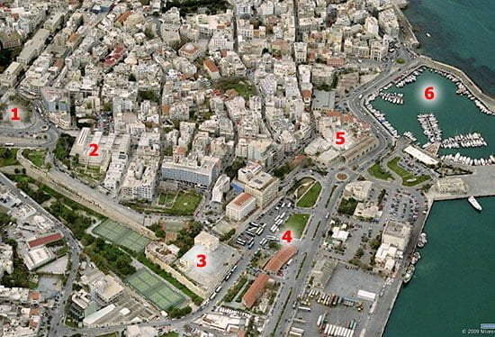
Greeks do not give you the past on a plate, you have to look for it. The last gate, the Gate of the Sand, Sambionara as it was known, is quite hidden now, although the walls are visible. Look for it in the streets behind the main bus station and the Megaron Hotel. It’s still there, still standing, still strong.
PHOTO:
No 1: Eleftherias Square
No 2:
Heraklion Archaeological Museum
No 3: Sabbionara bastion
No 4: Bus station to Chania, Rethymnon, Hersonissos, Malia, Agios Nikolaos, Ierapetra and Sitia
No 5:
No 6: Venetian harbour
A closer view of Sabbionara bastion
- Heraklion Walls, the history of the walls of Heraklion from the Byzantines until today
© explorecrete.com All Rights Reserved. Reproduction or copying without permission is prohibited.